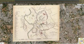
After last week's update with satellite imagery from the affected areas in Myanmar (Burma), Google Earth has just received a new update. This time, it is something that deals more with the past, but is of equal significance. The new layer has increased the number of available maps in Rumsey Historical Maps to a total of 120.
For those among you that are continuously interested in history and historical events, the new layer is certain to catch your eye. If you aren't familiar with what the Rumsey Historical Map Collection is, here is a small insight. David Rumsey, the famous map collector, has founded the Historical Map Collection, which goes by his name and now has over 17,400 maps online. The collaboration with Google Earth came somewhere in 2006, and initially numbered a total of 16 historical maps. Since then, the Historical Maps Gallery has seriously increased.
The recent addition brought no less than 100 new historical maps to Google Earth users. Besides the new data, the method by which users can find the maps and view them has also been improved. The new maps are displayed as icons on the Google Earth application, which the users can open and get more information about the specific historical map.
Among the new maps, American users will be able to see the first accurate survey of Yosemite Valley, dating from 1883. Ranging from the 18th to the 20th century, new maps of Los Angeles, San Francisco, Seattle, New York, Washington DC, Denver, Chicago, Moscow, St. Petersburg, Calcutta, Lima, Paris, Madrid, Rome, Beijing, Tokyo, Kyoto, and more are available. There is also a representation of the Celestial Globe dating back to 1792, which is also available in Google Sky.
The new design is really impressive and trying to identify the specific locations is easy, especially if you know the location of an existent historical monument or a geographical landmark.

 14 DAY TRIAL //