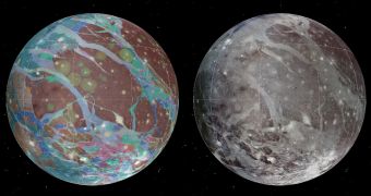
Researchers at the United States Geological Survey (USGS), led by Dr. Geoffrey Collins from the Wheaton College in Norton, Massachusetts, announce the creation of the first global geological map of the largest moon in the solar system, Ganymede.
The natural satellite is the seventh moon and third Galilean satellite outward from Jupiter, and features a diameter some 8 percent larger than that of Mercury – 5,268 kilometers (3,273 miles). However, the moon is less dense than the smallest planet in the solar system, featuring just 45 percent of its mass.
Ganymede was first discovered on January 7, 1610, by Galileo Galilei. There are, however, some reports from ancient Chinese sources suggesting that astronomer Gan De discovered an object around Jupiter in 365 BC, which was possibly Ganymede.
The reason why astronomers are so interested in this moon is because the four main Jovian moons – Io, Europa, Ganymede, and Callisto – hold the greatest potential of supporting life of any planet in the solar system except Mars. The same thing goes for the Saturnine moons Titan and Enceladus.
Though it took more than 400 years for Ganymede to receive a map, researchers at the USGS were finally able to develop a geological representation of the various characteristics present on its surface.
“After Mars, the interiors of icy satellites of Jupiter are considered the best candidates for habitable environments for life in our Solar System. This geologic map will be the basis for many decisions by NASA and partners regarding future US missions under consideration to explore these worlds,” says Laszlo Kestay, the director of the USGS Astrogeology Science Center.
Previous studies of Ganymede’s surface have revealed a very geologically-complex icy world, featuring two main types of terrain. The first type if very old and darkly colored, while the latter is brighter and younger, though still very old geologically.
“Three major geologic periods have been identified for Ganymede that involve the dominance of impact cratering, then tectonic upheaval, followed by a decline in geologic activity,” explains Ken Tanaka, who is a research geologist with the USGS.
“The highly detailed, colorful map confirmed a number of outstanding scientific hypotheses regarding Ganymede’s geologic history, and also disproved others,” adds USGS team member Baerbel Lucchitta.
“For example, the more detailed Galileo images showed that cryovolcanism, or the creation of volcanoes that erupt water and ice, is very rare on Ganymede,” the expert concludes.

 14 DAY TRIAL //