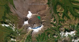
NASA experts recently used the Landsat 7 spacecraft to image the Aniakchak National Monument, in the Alaskan Peninsula. The view is centered on the massive caldera that represents the centerpiece of the Aniakchak National Preserve.
The geological origins of the massive, 6-mile (10-kilometer) wide caldera were confirmed only a few decades ago, during an expedition carried out specifically for this task. The weird shape this geological feature displayed was however observed for the first time back in 1922.
According to geologists, the caldera itself formed about 3,500 years ago. During the powerful explosion, the lava that was building up underneath the surface blew up roughly 3,000 feet (1,000 meters) of the mountain on top. This explains the massive size of the caldera.
This image was captured on September 15, by Landsat 7's Enhanced Thematic Mapper Plus instrument.

 14 DAY TRIAL //