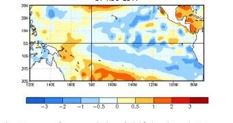
According to experts at the US National Oceanic and Atmospheric Administration's (NOAA) Climate Prediction Center (CPC), the La Niña phenomenon is beginning to reemerge in the tropical waters of the Pacific Ocean. Predictions indicate that it will continue to do so throughout the winter.
During the first half of 2011, this naturally occurring climate phenomenon led to extreme weather patterns around the globe, including the second-warmest summer on record for the United States.
It results from interactions between the ocean surface and the atmosphere, and has far-reaching, global effects. Its main feature is that the ocean in its area of effect becomes cooler than normal. Its counterpart, El Niño, produces warmer-than-average temperatures when it replaces La Niña.
The CPC is scheduled to release the official winter outlook for the US in mid-October, but it already advised NOAA to boost August's La Niña Watch to a La Niña Advisory. This move would make authorities more prepared in case of extreme weather.
If this La Niña winter will be anything like other, similar ones, then we could expect to see drier-than-normal conditions throughout the southern portions of the United States. The situation will be turned on its head in the north, where massive amounts of precipitations are expected to occur.
In other words, blizzards and snow storm might become common occurrence through this winter as well, similar to how they were over the past couple of years. When La Niña manifests itself – every 3 to 5 years – it has a 50 percent chance of being triggered in a back-to-back succession.
This is precisely what is happening now. After subsiding in May, the phenomenon is now returning gradually, although it should have theoretically been replaced by El Niño.
“This means drought is likely to continue in the drought-stricken states of Texas, Oklahoma and New Mexico. La Niña also often brings colder winters to the Pacific Northwest and the northern Plains, and warmer temperatures to the southern states,” says the deputy director of the CPC, Mike Halpert.
Based on the new data, the NOAA National Weather Service (NWS) is already compiling projections that will help both authorities and the general population become prepared for the extreme weather that apparently lies in store for the,.
The main goal of the NWS is to turn the United States into a Weather Ready Nation, a country that is capable of foreseeing and preparing for extreme weather conditions weeks or months in advance.
As global warming begins to change climate patterns worldwide, the incidence of such events is expected to increase drastically, especially if no mitigation measures are set in place.

 14 DAY TRIAL //