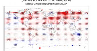
According to the conclusions of a new report released by experts at the US National Oceanic and Atmospheric Administration (NOAA), it would appear that last month was the fourth-warmest June recorded since records began, in 1880.
The report, entitled “State of the Climate Global Analysis, June 2012,” was compiled by scientists with the NOAA National Climatic Data Center (NCDC). It indicates that average land and ocean surface temperatures for last month were 0.63 degrees Celsius (1.13°F) above the 20th Century average.
Over the past 100 years, combined land and ocean surface temperatures were around 15.5°C (59.9°F). An interesting conclusion of the new report was that the June 2012 temperature levels for the Northern Hemisphere were the warmest ever recorded.
Temperature in this hemisphere were as much as 1.30°C (2.34°F) above average. This is a very sharp increase, considering that it will only take a 2°C warming from average levels to trigger a cascade of processes from which the planet will barely be able to recover.
At the global level, land surface temperatures for June were also the warmest ever recorded, at some 1.07°C (1.93°F) above the average. In other words, the world's oceans, which cover a significant portion of the Southern Hemisphere, were the only factor that kept temperature rise in check.
Ocean temperature levels recorded last month were the 10th warmest ever, NCDC scientists say. Averaging sea and land temperatures for January to June 2012, experts found that this interval was the 11th warmest on record, some 0.52°C (0.94°F) above the average.
NOAA experts point out that the new results are preliminary, and that they will most likely be refined even further as additional data are included in the models. Still, it is unlikely that the finished science product will reveal any significant discrepancies from this report.
“June 2012 also marks the 36th consecutive June and 328th consecutive month with a global temperature above the 20th century average. The last below-average June temperature was June 1976 and the last below-average temperature for any month was February 1985,” NCDC experts add.
Given the amount of data the team centralized for this research, establishing the likelihood of large-scale weather phenomena occurring was also made easier.
“NOAA's Climate Prediction Center issued an El Niño watch, and stated that there is an increased chance for El Niño beginning in July–September 2012,” the research team wrote in a press release.

 14 DAY TRIAL //