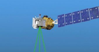
A new report published by the US Government Accountability Office (GAO) on Tuesday, April 15, reveals that the Advanced Topographic Laser Altimeter System (ATLAS), the main scientific instrument on the NASA Ice, Cloud and land Elevation Satellite (ICESat-2), will be delivered to the space agency at least 9 months later than originally planned.
The same document highlights that ATLAS continues to face challenges in its development process, despite efforts at NASA and its contractors to address these issues. ICESat-2 is a successor of ICESat, which operated from 2003 to 2010. Dataset continuity between the two missions is ensured by the NASA P-3 Orion aircraft, which carries out yearly flights under the aptly-named IceBridge mission.
When launched, ICESat-2 will carry a single scientific instrument. ATLAS is a space-born LIDAR (light detection and ranging) laser, which will emit pulses of light at a wavelength of 532 nanometers, in the optical part of the electromagnetic spectrum. The instrument is being developed by Fibertek, Inc.
The satellite will be deployed in a near-circular, near-polar orbit at an altitude of 496 kilometers (308 miles), which will allow ATLAS to create 3 different pairs of tracks on the ground with its lasers. Each pair will cover an area about 3.3 kilometers (2.05 miles) wide. However, the new report indicates that the instrument will not be ready on time.
The first hints of trouble with developing ATLAS emerged in October 2013, when NASA officials first started advancing the idea that ICESat-2 would not be ready on time. Originally, the mission was supposed to take off in July 2015 from Space Launch Complex 2W (SLC-2W) at the Vandenberg Air Force Base (VAFB), in California, aboard a Delta II rocket provided by the United Launch Alliance.
The conclusions listed in the new report support a recent NASA statement arguing that the launch date may slip from 2016 to at least 2018. This is a dire situation at the American space agency, since the ICESat-2 project is deemed to be of critical importance. This mission analyzes ice sheet mass elevation, a measure that is crucial for our understanding of how global warming influences polar regions.
Over the past few years, two flagship Earth-observation missions have been derailed at NASA. The Orbiting Carbon Observatory (OCO) spacecraft – the first satellite dedicated to monitoring atmospheric carbon dioxide concentrations ever created – was lost at launch on February 24, 2009, while ICESat-2 is currently being pushed back by another two years.
ATLAS is being assembled by Fibertek in Herndon, Virginia, based on specifications by engineers at the NASA Goddard Space Flight Center (GSFC) in Greenbelt, Maryland. “The instrument’s performance began to degrade in January 2013, one month after its plan was baselined at confirmation,” the new GAO report says, quoted by Space News.
The document adds that the 20 subsystems making up the LIDAR system were all in good working order, but says that the team in charge of ATLAS integration is still experiencing difficulties getting all of them to work properly together. Budget overruns caused by these delays are expected to exceed 15 percent.
Though officials from Fibertek Inc. say progress on their end is smooth, the GAO report disagrees. According “to project officials, the instrument’s most challenging subsystem is the optics subsystem, due to its very strict requirements. The project recently reported identifying several areas where requirements could be relaxed, which benefited multiple subsystems,” the document reveals.

 14 DAY TRIAL //