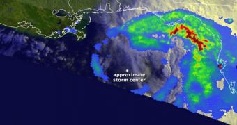
With the Atlantic Hurricane Season underway for a few weeks, Tropical Storm Debby is the fourth atmospheric event to be intense enough to receive a name. It formed on June 23, in the central parts of the Gulf of Mexico and has already drenched Florida in massive amounts of precipitations.
The image above was snapped using instruments aboard the Tropical Rainfall Measuring Mission (TRMM), which is a spacecraft operated jointly by NASA and the Japan Aerospace Exploration Agency (JAXA).
It shows both the high (redder) and low (bluer) amounts of precipitation that Tropical Storm Debby left behind as it first moved north, and then northeast. Though the atmospheric event does not feature very strong winds, it did manage to drench certain parts of Florida.
“The image shows a top-down view of the rain intensities within Debby. Rain rates in the center of the swath are from the TRMM Precipitation Radar (PR), while those in the outer swath are from the TRMM Microwave Imager (TMI),” NASA reports.

 14 DAY TRIAL //