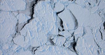
Scientists with Operation IceBridge, currently underway around the Arctic, have just returned from another research flight over Greenland. They also brought back pictures of what they saw above the ices, and the views are not encouraging.
They are again underlying the effects that global warming is having on the areas at and around the North Pole, as well as in Greenland. The latter holds massive amounts of ice reserves, which can cause massive floods around the world if they make their way into the Atlantic Ocean.
The goal of the Operation IceBridge Arctic 2011 campaign is to keep an eye on these changes. The survey has been going on for six years, and it has covered both the Arctic and the Antarctic since.
On March 26, experts with the endeavor returned from another scientific sortie, which this time produced14,092 images. All of the views were collected with the Digital Mapping System, (DMS).
The high-resolution digital camera is mounted aboard the P-3B airplane the American space agency has converted into a flying lab. US Naval Academy Oceanography Department Lieutenant Commander John Woods was a part of the new expedition, together with student Eric Brugler.
Both of them are members of the Sea Ice Thickness Observation Team within Operation IceBridge. They blogged about the things they saw during the recent flights on NASA Earth Observatory.
“Lots of people think of the Arctic as just a flat expanse of white. This couldn’t be further from the truth. There are all sorts of cracks (leads) and mountains (ridges), similar to tectonic plates,” Woods writes.
“The ice below is constantly moving via the winds and currents, and those forces acting on each piece of ice makes for a very dramatic seascape,” the expert goes on to say. He adds that the research aircraft flew a zig-zag pattern some 457 meters (1,500 feet) above the ice sheets.
This research project is meant to continue the legacy of the ICESat satellite, which was decommissioned a few years back. The spacecraft carried out the same measurements as IceBridge does today.
The purpose of the current endeavor is to fill in the gap in data collection until NASA can launch a new ice-mapping spacecraft.
“With IceBridge, we will continue monitoring the loss of sea ice in the Arctic which will not only help us determine the health of the sea ice cover, but whether the impact of sea ice losses are further impacting warming in the Arctic region,” explains Nathan Kurtz.
The expert, who was a member of the ICESat team, holds an appointment as a polar scientist at the NASA Goddard Space Flight Center (GSFC), in Greenbelt, Maryland.

 14 DAY TRIAL //