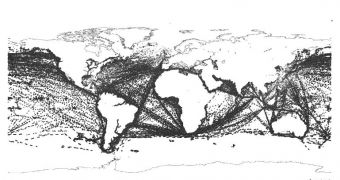
Officials at the European Space Agency (ESA) announce that an advanced scientific experiment aboard the ESA Columbus laboratory module is currently keeping track of all ships moving on the surface of the world's oceans. The tool, located on the International Space Station (ISS), was constructed specifically to determine whether such methods of monitoring, surveillance and statistics are efficient or not. The system, called Automatic Identification System (AIS), is very similar to the air traffic control system used on Earth for airplanes.
But only certain types of ships can be tracked, experiment managers say. Passenger carriers, international vessels, as well as large cargo ships, all have to carry what are known as ‘Class A’ AIS transponders. These instruments continuously broadcast identification and navigation data, and update the information on a regular basis. Port authorities and coastguards, for example, use the AIS system to track incoming and outgoing ships. The thing about this approach is that it only has a range of 74 kilometers in any direction, which is less than 40 nautical miles.
However, scientists observed some time ago that the VHF signal reached very high up in altitude. Even the ISS, hundreds of kilometers above the Earth's surface can pick it up. “The COLAIS (Columbus AIS) experiment was switched on at the start of June. To give an idea, more than 90,000 Class A AIS messages were gathered between 19:00 GMT on 2 June and 09:00 GMT the following day, giving a global overview of maritime traffic” explains the ESA COLAIS project manager, Karsten Strauch. Teams of scientists in charge of analyzing the signals from this experiment get their data from the Oberpfaffenhofen, Germany-based Columbus Control Center (CCC).
“We are currently testing the NORAIS receiver, built by the Norwegian Defense Research Establishment and Kongsberg Seatex. In three months’ time, the Station crew will switch it with a second receiver called LUXAIS, the work of Luxembourg companies Luxspace and Emtronix. For the next two years we will go on swapping between these receivers,” the official adds. The COLAIS instrument has a bright future, analysts say. Its data could conceivably be merged with information obtained by remote-sensing satellites, creating an integrated view of the world's ship traffic at a glance.

 14 DAY TRIAL //