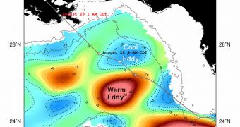
A team of experts at the NASA Jet Propulsion Laboratory (JPL) in Pasadena, California, has just finished an analysis of Hurricane Isaac, currently a Category I Hurricane making landfall in Louisiana. The study shows why Isaac is not as strong as Category 3 Hurricane Katrina was in 2005.
The latter was a Category 1 as it moved over Florida, but quickly gained strength upon reaching the warm waters of the Gulf of Mexico, turning into a Category 5 storm. Eventually, as it made landfall in Louisiana, its intensity was reduced to Category 3.
In the case of Hurricane Isaac, cooler waters in the Gulf prevented it from picking up too much Steam, and marching inland as a more intense storm. Its maximum sustained winds currently reach 70 knots (80 miles/128.7 kilometers per hour).
Another important difference between the two hurricanes is that Isaac took a different path over the Gulf altogether. JPL scientists say that this was an instrumental factor in keeping it relatively tame.
When Katrina passed over the Loop Current, a warm water circulation feature of the Gulf Stream, it moved from Category 1 to Category 5 in just nine hours. This increase can be attributed exclusively to the higher-temperature water.
The research team used satellite altimeter instruments to identify the location of the Loop Current, and also to find warm-water eddies in the Gulf. Since temperatures are higher at these locations, water levels also increase slightly, and the sensitive instruments aboard NASA satellites can see them.
The NASA/French Space Agency Jason 1 and Ocean Surface Topography Mission/Jason 2 satellites are extremely well-suited for performing this type of investigations. Using datasets sent back to Earth over the past week, the team determined the location, direction and speed of currents throughout the Gulf.
“This color-enhanced image of sea surface heights […] shows Isaac's path through the Gulf. The storm skirted around the Loop Current, then caught the outer edge of a warm eddy before passing directly over a cold eddy,” the team says in a statement.
“The storm's track away from the Gulf's warmest waters has helped to keep Isaac from intensifying rapidly, as Hurricanes Katrina and Rita did in 2005,” JPL experts go on to say.
“Warm eddies have high heat content and great potential to intensify hurricanes, whereas cold eddies have low heat content and may even cause hurricanes to weaken, as was the case with Hurricane Ivan in 2004,” they conclude.

 14 DAY TRIAL //