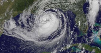
Using the NASA/NOAA GOES-13 satellites, which are part of the Geostationary Operational Environmental Satellite constellation, experts in the United States snapped a new image of Hurricane Isaac from Earth's orbit, showing the full extent of the massive storm.
This view was collected yesterday, August 28, at around 10:25 am EDT (1425 GMT). At that time, the storm had reached the Carolinas, in the east, and Eastern Texas, in the west. Currently, it is affecting Western Florida, Alabama, Mississippi and Louisiana.
Cataloged as a Category 1 hurricane, the weather event is the ninth named storm in the 2012 Atlantic hurricane season. It began developing on August 21 and evolved into a tropical storm hours later.
Hurricane Isaac has already caused moderate damages and loss of lives in Haiti, the Dominican Republic and Cuba. The storm is still ongoing and is expected to strengthen before it lets up.

 14 DAY TRIAL //