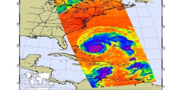
Hurricane Earl, currently a Category Four storm on the Saffir-Simpson scale, has recently been imaged by a collaboration of American researchers, which includes scientists from NASA and NOAA.
The experts are very interested in how this tropical cyclone will develop over the next few days, considering that the peak of the 2010 Atlantic hurricane season is just some 10 days away.
In its first half, the season was relatively quiet, say researchers based in Pasadena, California, at the NASA Jet Propulsion Laboratory (JPL). This is not the case now.
At this point, there are three tropical cyclones in the Atlantic, as Hurricane Earl is joined by tropical storms Fiona and Gaston. Satellites of the American space agency are keeping an eye on all of them.
In collaboration with experts at the US National Oceanic and Atmospheric Administration (NOAA), and using combined assets, NASA crews are conducting exhaustive studies of the storms.
“As of 5 pm EDT on Sept. 1, Earl was located about 1,010 kilometers (630 miles) south-southeast of Cape Hatteras, N.C., moving to the northwest at 28 kilometers per hour (17 mph),” JPL experts say.
“The core of Earl is expected to approach the North Carolina coast by late Thursday with hurricane-force winds. Tropical-storm-force winds are likely to reach the East Coast from Virginia northward to New Jersey by early Friday, Sept. 3,” they add.
At this point, analysts expect that Earl will start to weaken in a few days, but experts still need to observe it. Before dissipating in the northern Atlantic, Earl may decide to take a detour around New York City.
NASA has already used a variety of satellite instruments to produce numerous views of Earl, which provide meteorologists and atmosphere researchers with a wealth of new data.
Some of the instruments used include the Atmospheric Infrared Sounder (AIRS) and the visible light camera on the Aqua satellite, and the Multi-angle Imaging SpectroRadiometer (MISR) instrument on NASA's Terra spacecraft.
These tools capture images depicting Earl in infrared and visible light as well, which helps researchers keep an eye on its inner workings.
Maps of global wind speeds have also been produced, using data from the NASA Jason-1 and Ocean Surface Topography Mission (OSTM)/Jason-2 satellites.
Over the coming days and weeks, NOAA, NASA, and JPL will continue to monitor the situation.

 14 DAY TRIAL //