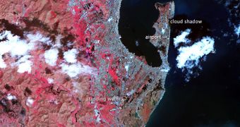
The image above was collected by the Advanced Spaceborne Thermal Emission and Reflection Radiometer (ASTER) instrument on the NASA Terra satellite. It shows what remains of the city of Tacloban, in the Philippines, after it was struck by Super Typhoon Haiyan on November 8, 2013.
This tropical storm was one of the most violent storms ever recorded on Earth. It killed more than 10,000 people across the country, and nearly razed the entire city of Tacloban when it made landfall near it with winds reaching 315 kilometers (195 miles) per hour.
Experts say that these winds produced a massive wall of water around 7.5 meters (24.6 feet) tall, which washed over the town. The city itself lies just 5 meters (16 feet) above sea levels. This ASTER image shows Tacloban as visible from low-Earth orbit on November 15.
The areas where the storm surges rushed in are shown in tan, since they were covered by mud. The peninsula housing the city's airport was almost entirely wiped out, with only a handful of buildings having survived the massive waves. At this point, atmospheric scientists are considering creating a new category for Super Typhoon Haiyan.

 14 DAY TRIAL //