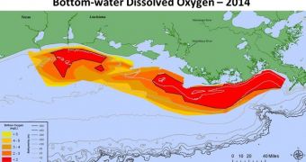
Measurements carried out just a few days ago indicate that the so-called dead zone that came to form in the Gulf of Mexico this year presently spans over approximately 5,052 square miles (roughly 13,084 square kilometers).
The measurements, taken between July 27 and August 2, are the work of researchers with the National Oceanic and Atmospheric Administration (NOAA), and the Environmental Protection Agency (EPA) in the US.
In case anyone was wondering, the phrase “dead zone” is not used to describe a region hit by a zombie apocalypse or anything of the sorts. Simply put, a dead zone is an area with a very low oxygen content.
Dead zones are usually birthed by nutrient runoff that encourages algal blooms. Specifically, studies have shown that having one too many algae grow in one region affects water quality by depleting oxygen resources.
“Dead zones, also called hypoxia areas, are caused by nutrient runoff from agricultural and other human activities in the watershed and are highly affected by river discharge,” the National Oceanic and Atmospheric Administration writes on its website.
“These nutrients stimulate an overgrowth of algae that sinks, decomposes, and consumes the oxygen needed to support life in the Gulf,” researchers working with the Administration go on to explain these phenomena.
This year's summer dead zone in the Gulf of Mexico is considerably smaller than the one which was documented last year and which covered an area of about 5,840 square miles (some 15,125 square kilometers). It is, however, big enough to affect local marine ecosystems.
This is because there aren't all that many aquatic creatures that have the necessary set of skills and anatomical particularities to be able to survive in waters depleted of nearly all their oxygen content by algal blooms and subsequent die-offs, NOAA and EPA specialists say.
Since dead zones that come to form in the Gulf of Mexico are caused by nutrient runoff from agricultural practices and other human activities, efforts are now being made to control their development by reducing environmental pollution.
The end goal is to have the Gulf of Mexico eventually accommodate for dead zones spanning over just 1,900 square miles ( 4,920 square kilometers). To put things into perspective, it need be said that the largest dead zone to have until now been measured in this part of the world encompassed 8,481 square miles (21,965) and was recorded in 2002.
The smallest one, on the other hand, was documented quite a while ago, in 1988, and covered just 15 square miles (38.8 square kilometers). Over the past half a decade, the average size of dead zones in the Gulf of Mexico has been one of roughly 5,500 square miles (14,244 square kilometers).

 14 DAY TRIAL //