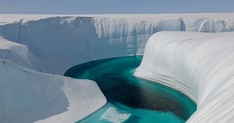
Researchers have long been aware of the fact that the ice sheet covering about 80% of Greenland is a contributor to rising sea levels. Still, it looks like previous investigations are guilty of having underestimated just how big a contributor to sea level rise this ice sheet really is.
Thus, a new paper says that it is possible that twice as much water leaves Greenland on a regular basis than previously estimated. This is because past studies focusing on the ice sheet covering this corner of the world failed to document one very important source of meltwater.
The study in question, authored by researcher Marco Tedesco with the City College of New York and his colleagues at the University of California, Los Angeles in the US, was published in the latest issue of the journal Proceedings of the National Academy of Sciences.
The well-documented sources of Greenland meltwater
In the report documenting their work, the researchers behind this investigation explain that, when studying Greenland's ice sheet in the past, scientists zoomed in on so-called aquamarine lakes and mammoth chunks of ice sliding into the ocean as major contributors to sea level rise.
As detailed in the journal Proceedings of National Academy of Science, these aquamarine lakes are essentially massive bodies of water that Greenland's ice sheet accommodates for and that, every now and then, abruptly drain. The chunks of ice, on the other hand, are iceberg precursors.
Having reached the ocean, water originating from Greenland's aquamarine lakes and from the icebergs birthed by the sheet covering it causes sea levels to rise. The thing is that, according to scientist Marco Tedesco, there is one other source of water that remained undocumented for decades.
The sea level rise contributor everyone failed to notice
City College of New York specialist Marco Tedesco and fellow researchers say that the surface of the ice sheet covering Greenland is criss-crossed by a whole lot of rivers and streams that form whenever temperatures in the region increase to a considerable extent.
“It’s the world’s biggest water park, with magnificent and beautiful – but deadly – rushing blue rivers cutting canyons into the ice,” scientist Laurence C. Smith with the University of California, Los Angeles, describes these rivers and streams that form atop Greenland's ice sheet.
Although pretty much ignored by previous investigations, it appears that these flowing bodies of water contribute to sea level rise as well. In fact, it is estimated that, together, they deliver about as much water to the ocean as the aquamarine lakes and the icebergs combined, maybe even more.
True, the rivers and streams also carry their water to land. However, it appears that the amount of water they take to the ocean is greater than assumed. For instance, the Isortoq River, which drains about 20% of the ice sheet rivers and streams, delivers 25% less water to land than indicated by past studies.
“More research is definitely needed,” researcher Marco Tedesco commented on the outcome of this investigation. “Greenland is really the big player for sea level rise in the future, so improving climate models is extremely crucial,” he added.

 14 DAY TRIAL //