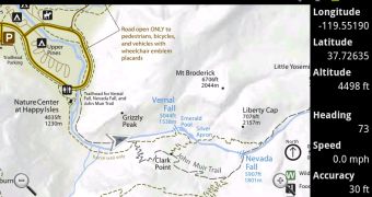
Google has open sourced a very interesting tool that it's also making available as an Android app. The tool, dubbed Custom Maps enables users to take a photo of a real world map, of any kind, sync it with Google Maps and then use it as a GPS map, the same they would use Google Maps.
The idea is quite simple, but it can prove useful in many situations. You can snap a photo of an existing map, or get one from the web or your computer, then match it to the location in Google Maps.
After that, you'll be able to add your GPS-determined location on top of the map and use that image as a map tile, instead of the regular Maps image.
"The Custom Maps app allows for easy creation of digital maps from any map image," Marko Teittinen from the Google Geo Team wrote.
"The image can be a photo of a paper map, a photo of a brochure map, or a picture of the map posted at a trailhead or at the entrance to an amusement park," he explained.
"It could also be a .jpeg or .png image hosted on the internet or a screenshot of a PDF map. All you have to do is choose two (or more) matching points that are common to both the map image and Google Maps, and Custom Maps can show your GPS location on the map," he added.
There are several advantages to this. On the one hand, it's easy to see exactly where you are since you're using the actual map with your location marker.
But the tool also makes it easier to work with large images, since it makes use of the same techniques Google Maps uses to provide you with detailed images without completely slowing down your device.
One interesting feature is that Custom Maps stores the new maps as KMZ files which are simple Zip archives, so the map images can be extracted and manipulated. It also means that you can import the KMZ files into Google Earth to use the customized map.
The source code for the tool is available under a permissive Apache License 2.0. Google plans to add more features to it, like the ability to measure distances and even to geolocate images without Maps and without a data connection.

 14 DAY TRIAL //