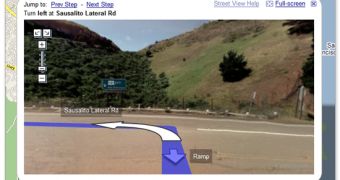
Until now, the Google Maps driving directions has proved to be quite a useful function because users could get the simplest route between two defined points without too much effort. On the other hand, Google Maps Street View is probably the most popular feature of the web-based mapping service because it allows consumers to view street-level 360 degree panoramas from multiple locations in the world. Since these two functions are pretty well-developed and have gathered an important audience, the Mountain View-based company Google has decided to mix them in order to offer a single and more advanced feature.
The resulting service works almost like a traditional GPS device: you enjoy high-resolution street-level photos and, at the same time, you get driving directions that let you reach your destination point. Just like in the racing games where you get those direction arrows showing the road you must follow.
"By viewing Street View images alongside directions, drivers have visual context for intersections and action points along their route, enabling them to be aware of landmarks and other factors such as tolls, speed limits, size of the road, and the availability of parking at their destination," Google explained in a press release published today.
For those of you who don't know, Google Maps Street View is currently available in no less than 44 locations in the United States. However, there have been signs that Google intends to move Street View abroad, in Canada and even in Europe. For instance, the Street View cars, which are used by Google to capture the high-resolution photos implemented in Street View, have been spotted in Italy, which clearly shows us that this may be the first European country to get the Google Maps function. However, Google avoids commenting on this matter so there's no official confirmation whether Street View arrives in Europe or not.

 14 DAY TRIAL //