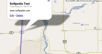
Google's web-based mapping utility is now able to calculate the distance between two points selected by you. Basically, it is implemented into the My Maps side of Google Maps, a special function of the product that brings map creation capabilities straight to the user's mouse. My Maps help you build your own map, define your own routes, place landmarks and add lines in a matter of seconds. Using the new feature, you're even capable of calculating the distance between two points such as cities or your entire trip route. The distance measurement tool appears every time you draw a straight line and automatically updates the number as you extend the route.
"We've added distance measurement to the line tool. Whenever you draw a line, you'll see the current distance as you move the mouse and add new points. The distance is also displayed in the info window when you click on your completed line," Keith Golden, Software Engineer, Google Maps, wrote on the official blog of Google Maps.
Until now, you were able to calculate the distance by using third-party technologies such as this one which is also based on Google Maps. However, the entire project was not built by the search giant so in order to use the Google Maps Distance Calculator you have to leave the page of the mapping tool and connect to this one.
In the recent period, Google Earth and Google Maps, the two mapping solutions developed by the Mountain View company received lots of new functions. Take the example of Google Earth which was recently updated with the revolutionary Google Sky, a special feature that brings the starts and the galaxies straight on your desktop. In addition, the company bundled some secret functions, such as the Flight Simulator which enables the viewers to fly with a virtual plane over the locations displayed by Google Earth.

 14 DAY TRIAL //