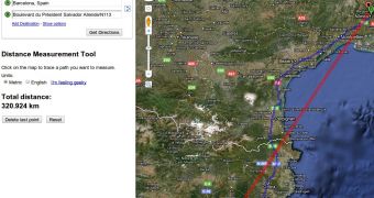
One of the reasons why Google introduced the Labs feature was so that it had a place to add interesting features that might not be useful to a larger audience, but that could be very valued by some. One such feature has just been introduced to the Google Maps Labs section, distance measurements. As the name clearly reads, it’s a tool that enables you to calculate the distance between two or more points on Google Maps.
To activate the tool, you have to go to the Labs section, you can click on the small Labs icon in the upper-right corner, and enable the “Distance Measurement Tool.” After you’ve saved the changes, you will see a small ruler icon in the lower-left corner of the map. Clicking on that will bring up the tool, which is straightforward to use.
Just click to set a starting point and then click again at the location of the destination. You can add more than just a starting and an end point and the tool will add up the distances between all points. Once you have selected two or more points, you’ll see how far apart they are, in a straight line.
By default, the distance is shown in kilometers, using the Metric system, but you can choose the Imperial (English) system for miles. And if that’s not enough, you can select “I’m feeling geeky” and choose from a myriad of measuring units, from the ancient ones like Greek and Egyptian cubits to the scientific ones like Parsecs and Angstrom to the layman ones like American football field.
It’s a pretty interesting tool, but, unless you plan to levitate from point A to point B, it’s not of much practical use, at least not for directions. But if you ever wanted to know how far you were from either the local store or Mount Everest, now you can. [via Google OS]

 14 DAY TRIAL //