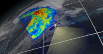
Officials with NASA and the Japan Aerospace Exploration Agency (JAXA) have just released the first images compiled from data returned to Earth by their latest joint mission, the Global Precipitation Measurement (GPM) Core Observatory. The satellite was launched into space less than a month ago, but it is already producing relevant scientific data.
The environmental research mission was boosted in a geocentric, low-Earth orbit aboard a Mitsubishi Heavy Industries H-IIA 202 rocket, which took off from the Yoshinobu 1 launch pad at the Tanegashima Space Center, in Japan. Liftoff occurred on February 27, 2014. The mission is managed by experts at the NASA Goddard Space Flight Center (GSFC) in Greenbelt, Maryland.
The main contribution that JAXA made to the instruments aboard the GPM Core Observatory is the Dual-frequency Precipitation Radar (DPR), an asset capable of producing beautiful, 3D cross-sections of massive storms, cyclones, hurricanes and other extreme atmospheric events. NASA contributed with the GPM Microwave Imager (GMI) instrument, which observes precipitations over a large swath.
The image above was collected on March 10, as the satellite was flying over the northwestern parts of the Pacific Ocean. Some 1,600 kilometers (1,000 miles) away from the coasts of Japan, the spacecraft identified a large cyclone, which was thoroughly dissected by both DPR and GMI. GPM scientists determined that this event was an extra-tropical cyclone, of the type that occurs beyond the tropics.
“It was really exciting to see this high-quality GPM data for the first time. I knew we had entered a new era in measuring precipitation from space. We now can measure global precipitation of all types, from light drizzle to heavy downpours to falling snow,” explains Gail Skofronick-Jackson, who is a scientist for the GPM project at GSFC.
Mission controllers say that GMI is able to observe storms with a diameter as small as 5 to 15 kilometers (3 to 9 miles). This resolution is much better than what can be found on GPM's predecessor, the NASA/JAXA Tropical Rainfall Measurement Mission. This satellite launched back in 1997. GMI measures the natural energy radiated by Earth and rain through its 13 channels.
The accuracy of GMI measurements is further improved through the use of the DPR instrument, which adds an extra, high relief dimension to GPM's observations. Both instruments “return independent measurements of the size of raindrops or snowflakes and how they are distributed within the weather system,” says Bob Meneghini, who is a DPR scientist at GSFC.
“DPR allows scientists to see at what height different types of rain and snow or a mixture occur – details that show what is happening inside sometimes complicated storm systems,” the expert explains.
In addition to keeping an eye on Earth's droughts and floods, the GPM Core Observatory also constructs a database of new knowledge on our planet's hydrological cycle. Understanding the connections between these processes and events such as droughts and floods is one of the primary scientific objectives of the entire mission.

 14 DAY TRIAL //