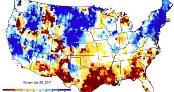
Experts at NASA were surprise at the extent of the Texan droughts revealed by new groundwater distribution maps produced by the Gravity Recovery and Climate Experiment (GRACE) satellites.
A joint mission between NASA and the German Aerospace Center (DLR), GRACE are highly-advanced spacecraft, capable of conducting a host of studies, including on droughts. They were pointed on Texas because of the severe lack of water the state experiences.
According to statistics, this year's droughts caused extensive wildfires – more than usual – cattle to be sold in large numbers due to lack of pasture, and crop failure. GRACE data indeed shows that groundwater levels are at their lowest in 60 years.
The datasets the satellites returned to Earth were centralized at the University of Nebraska-Lincoln (UNL) National Drought Mitigation Center (NDMC). The latest maps were released on November 29, and made available through the Center's official website.
Experts at the NASA Goddard Space Flight Center (GSFC) are generating new GRACE maps every single week, based on gravity field data compiled by colleagues at the NASA Jet Propulsion Laboratory (JPL), in Pasadena, California, and the Austin-based University of Texas Center for Space Research.
As the image to the left shows, Texas is covered in maroon, indicating severely depleted water concentrations. According to GSFC hydrologist Matt Rodell, it will take months for Texan water reserves to recover following this drought.
“Even if we have a major rainfall event, most of the water runs off. It takes a longer period of sustained greater-than-average precipitation to recharge aquifers significantly,” the researcher explains.
He adds that the twin GRACE spacecraft conduct their studies by analyzing subtle changes in Earth's gravitational field. These disturbances are generated by water moving underground, or not moving at all, as is the case with Texas.
“All of these maps offer policymakers new information into subsurface water fluctuations at regional to national scales that has not been available in the past,” explains NDMC investigator Brian Wardlow.
In addition to monitoring drought or flood potentials throughout the country, the GRACE satellites can also be used to differentiate between long- and short-term droughts. This helps inform authorities about what to expect when it suddenly stops raining.

 14 DAY TRIAL //