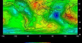
Just two short years following its launch, the GOCE satellite has completed a full-globe gravity map of our planet. This finally reveals the world's 'geoid' reference shape, and it was all possible thanks to the spacecraft that has been dubbed the most beautiful satellite in the world.
The Gravity field and steady-state Ocean Circulation Explorer (GOCE) launched in March 2009, with the express purpose of analyzing the smallest variations in Earth's gravitation pull at various locations.
The way it was able to do so was the advanced technology that went into it. The ion thrusters that propel it are also among the most important instruments of the mission.
In order to conduct its investigation, the satellite had to be placed in a very unusual and low orbit, which means that its engines had to work extra to keep GOCE afloat. At the same time, due to the delicate nature of the measurements it was conducting, the spacecraft could not be jolted.
Ion propulsion provided the way out of this problem. It move the spacecraft so smoothly, that the onboard computers can compensate for this movement, guaranteeing the quality of final datasets.
The mission is the most complex and innovative ever done by the European Space Agency (ESA).
“The number of 'firsts' it embodies led to many challenges for our scientists, engineers and more than 40 companies involved in building the satellite,” explains the director of ESA Earth Observation Programs, Volker Liebig.
“I am happy to announce that their hard work and dedication have paid off. The satellite has recorded the measurements necessary to enable us to produce a high-resolution map of the 'geoid' that is far more accurate and has a much higher spatial resolution then any other dataset of this kind,” he adds.
According to experts, the geoid is the imaginary shape of the global ocean, as it would look like without the influence of tides and currents. Knowing the geoid enables scientists to measure ocean circulation, ice dynamics and sea level changes with tremendous precision.
This will come in handy when it's time to assess the actual influence that climate change and global warming have on Earth's atmosphere, oceans and lands. The geoid will become available to experts in the coming weeks, after all GOCE data are calibrated and processed.
On top of the excellent return it made, the satellite is also still operational, and has sufficient fuel to continue functioning until the end of 2012. The fuel savings are owed to the diminished activity of the Sun over the past two years.
“By nearly doubling the mission’s lifetime, GOCE data will provide an even better gravity field map and geoid products. Once the gravity models are completed, they will be made available to all users, free of charge in line with ESA's data policy,” concludes GOCE mission manager Rune Floberghagen.

 14 DAY TRIAL //