The drought conditions affecting northeast Africa are so intense that the United Nations have declared a famine in the area. More than 11.5 million people in Somalia, Ethiopia, Kenya and Djibouti are affected by the worse drought to hit the area in several decades.
Experts with the US Department of State (DoS) say that the region is battered by warm weather and arid conditions the likes of which have only been seen in several other instances throughout history.
NASA is keeping a close eye on the situation via its satellites, and the agency's Jet Propulsion Laboratory (JPL), in Pasadena, California, is already creating databases to help experts understand why such a massive drought occurred.
Climatologists believe that strong La Niña conditions that prevailed in late 2010 and early 2011 may be responsible for causing this effect. The ocean-atmosphere coupled event acts by modifying the temperatures of surface water in the Pacific Ocean.
It also influences air pressure over the same area, which in turn controls precipitation patterns over most of the world. Historically speaking, La Niña events have always brought drought to east Africa.
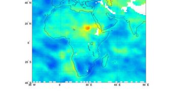
JPL experts have already created a new climatology map for the region. The dataset is put together by averaging 9 years-worth of observations collected by the Atmospheric Infrared Sounder (AIRS) instrument on the NASA Aqua satellite.
Primarily, AIRS is focused on studying surface relative humidity, providing climate scientists with worldwide data that can be fed directly into existing climate models. This measure represents the percent of water vapor in the air nearest to Earth's surface, where people, animals and plants live.
“Areas shown in greens, yellows, oranges and reds represent regions that are drier in July 2011 than the average of all the previous Julys dating back to 2003,” a NASA press release on the situation explains.
“The driest conditions, shown in red, are found in northeast Africa, while large regions throughout the Middle East are moderately dry. Areas in blue were moister in 2011 than in the previously studied years,” the statement adds.
“White areas represent data voids caused primarily by the effects of mountain and highland topography. In regions that are traditionally dry, the additional drying of more than 15 percent relative humidity is very stressful to crops, causing them to dry out and die,” the agency says.
At this point, experts cannot predict when the drought will end. What is certain at this point is that the people currently living in extreme poverty and starvation need to be helped as soon as possible.

 14 DAY TRIAL //