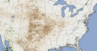
Using their Moderate Resolution Imaging Spectroradiometer (MODIS) instruments, the NASA Terra and Aqua satellites were able to compile a map showing the extent of dried-up vegetation in the continental United States. The images used for this study were collected this August.
The US Drought Monitor reports that, at the end of August, nearly 67 percent of the country's surface was plagued by drought. Around 40 percent of the surface was parched, and therefore cataloged as being hit by severe or extreme drought.
The image above shows the areas that were most severely hit. These include the central region of the US, and northern Mexico. Agricultural crop yields are expected to be drastically affected by this summer's lack of precipitations.
“By far, this is the driest year we have seen since the launch of MODIS. I am struck by the extraordinary depth and spatial scale of this drought,” says NASA Goddard Space Flight Center vegetation and food security researcher, Molly Brown.

 14 DAY TRIAL //