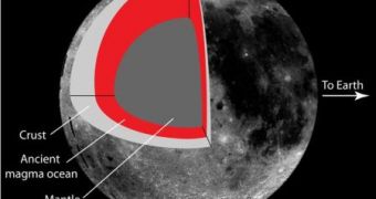
The far side of the Moon is always unseen by the naked eye on Earth, but a team of researchers at the University of California, Santa Cruz, have found a way of describing how it looks, thus revealing a bit more about its history.
The near and far sides of the moon are very different from one another and understanding where did these differences came from, could give an insight into the early days of Earth's natural satellite.
People first saw pictures of the 'dark side' of the moon in 1959, from unmanned probes, and then again, during the Apollo mission in 1968, SPACE.com reports.
What nobody managed to explain until now, is the bulge of high soil on the far side of the moon, called the lunar far side highlands, some 1.2 miles (1.9 km) higher than the soil on the near side.
The amazing thing is that the team from the University of California, Santa Cruz, proved through mathematics that the highlands are the result of tidal forces acting early in the moon's history when its solid outer crust floated on an ocean of molten rock.
“What's interesting is that the form of the mathematical function implies that tides had something to do with the formation of that terrain,” said Ian Garrick-Bethell, an assistant professor of Earth and planetary sciences at UC Santa Cruz, and first author of a paper published in the November 11 issue of Science.
This landform on the far side of the moon seems to be the oldest lunar feature seen yet, since it lies beneath the ancient South Pole-Aitken Basin, and its mathematical reasoning is similar to the tidal effects Jupiter had on its moon Europa.
“Europa is in many ways different from the moon, but early on, the moon had a liquid ocean under its crust, and it likely shares that in common with present-day Europa.
“The ocean for the moon was of liquid rock, however, not water,” Garrick-Bethell said.
On one hand, on Earth, the moon causes tides, and on the other hand, the Earth is pulling at the moon.
The paper he published says that the lunar highlands were formed through the tidal heating of the moon's crust some 4.4 billion years ago.
This was possible because at that time, the crust of the moon was decoupled from the mantle below it by an ocean of magma, so the gravitational pull of the Earth caused distortions that were later frozen in place.
Garrick-Bethell said that the phenomenon “it's still not completely clear yet, but we're starting to chip away at the problem.
“People have been thinking about tidal explanations for the large-scale structure and shape of the moon for at least 100 years.
“The new thing here was to look at only one specific region of the moon that is very old, rather than to test the hypothesis over the moon as a whole, which was done previously.
“As a whole, the moon exhibits a wide range of geologic processes, some young and some old, so I don't think it's fair to explore it as a whole.”
The mathematical function that describes the shape of the moon's bulge can account for about one-fourth of the moon's shape, Garrick-Bethell explained.
Obviously, there are still some mysteries that subside, like what made the nearside so different, but Garrick-Bethell said that these findings yield insight into the fundamental processes that built the lunar crust.
"I would like to map out how this terrain may actually extend to other parts of the moon, and encompass even more surface area than we initially report," he added.

 14 DAY TRIAL //