Scientists in the United States are about to begin a new airborne science campaign, that will target the so-called “atmospheric rivers” that develop in Earth's atmosphere. These formations have been studied only a little in the past, although they are extremely important for weather patterns around the globe.
These “rivers” are in fact very narrow regions in our planet's atmosphere that are responsible for channeling huge amounts of water vapors from one location to the other. Some of them even go across the Pacific Ocean, and other swaths of land and sea as well.
While they may seem inconsequential at first, these narrow passages can transport seven times the average amount of water that the Mississippi River puts in the Gulf of Mexico. That's enough to flood the state of Maryland in 1 foot (0.3 meters) of water.
During the ARkStorm major emergency preparedness scenario, the US Geological Survey (USGS) drew attention to these formation. Experts at the organization said that, if several atmospheric rivers strike California, then they could cause a real disaster.
The scenario included such factors as mudslides, strong winds and flooding. The bottom line the USGS drew showed that the devastation such an interplay of factors would cause would produce a lot more damage than Hurricane Katrina did back in 2005.
After the scenarios was presented, the US National Oceanic and Atmospheric Administration (NOAA) decided to lead a cross-agency, multi-disciplinary observations campaign on these rivers in the sky.
The airborne field campaign called Winter Storms and Pacific Atmospheric Rivers (WISPAR) is slated to begin on February 11, and will include scientists, aircraft and sensors from NASA and the Jet Propulsion Laboratory (JPL), in Pasadena, California.
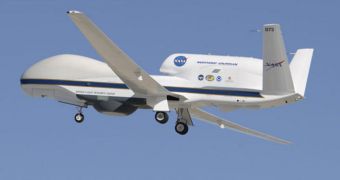
One of the assets the American space agency will deploy will be the Global Hawk air drone, which is being operated by experts at the NASA Dryden Flight Research Center, in Southern California.
It's job will be to study atmospheric rivers currently developing above the Pacific Ocean, off the coast of Hawaii, during several 24-hour flights. The UAV can remain airborne for prolonged periods of time, as it does not need alert pilots to operate. Some of its functions are automated.
Instruments aboard the Global Hawk will conduct measurements of atmospheric parameters such as temperature, wind, humidity and so on. But the main tool aboard is a JPL-built water vapor sensor.
The High-Altitude Monolithic Microwave Integrated Circuit Sounding Radiometer (HAMSR) can easily identify and measure heat radiation emitted by oxygen and water molecules, which allows experts to determine their temperature and density.
Experts hope that using HAMSR will provide them with the data they need to make sense of atmospheric water flows above that area of the Pacific Ocean.

 14 DAY TRIAL //