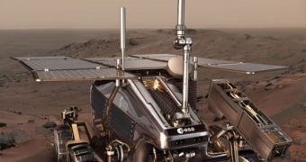
The European Space Agency (ESA) is currently working to develop and integrate all the systems required for its future mission to the Red Planet, the ExoMars rover. The robot, which is impressive in size, will navigate the red sands and analyze objects of interest on the surface, but its primary goal will be to look for life. Recently, a large step forward was taken, when mission engineers conducted a primary test of the future rover's cameras at a quarry in southern England, the BBC News reports.
In addition to the cameras, dedicated processing software also underwent testing. Once completed, the rover will feature a large number of cameras, and it will be up to the software and its designers to integrate information from all of them into a comprehensible set of data. According to design blueprints, it will feature no less than eight cameras at the front. Two stereoscopic, wide-angle cameras will snap panoramic, 3D views of the Martian landscape. Two pairs of cameras will be installed on its sides, and act as hazard detectors. Two additional ones in the front will serve for navigation.
It's the job of the EU PRoVisG (Planetary Robotics Vision Ground Processing) project to ensure that all information obtained from these cameras is integrated correctly into a highly detailed, 3D image of the rover's environment. One task that the software will have to perform is, for example, to tag a certain image from the wide-angle cameras with the exact location at which it was taken, based on input taken from the other instruments. Designing such systems for Mars is not as easy as making them here on Earth.
Any device sent to the planet needs to be able to sustain launch vibrations, months of travel, hot landings and freezing temperatures, all while being constantly hit by high-energy cosmic rays. Engineers at ESA, or any other space agency for that matter, need to design their rovers, landers and orbiters around these constraints. Additionally, they have to minimize the amount of data that the robots have to beam back, as a data send-return trip to Mars lasts for as much as 20 minutes.
According to experts, the new video system will allow future space explorers to recognize various locations on the planet. “From the images, we can generate 3D elevation maps – 3D representations that you can actually explore. Once you've created that model you can use all the surface textures you've gained from the imagery, and you've got an environment that people can go and explore. You can become almost like a field geologist, in the field on Mars,” EADS Astrium Lead Engineer Lester Waugh adds. The company coordinates the UK efforts on the PRoVisG project.
“It's a bit like Google street view: you can go down to street level and explore the environment so that when you drive into the place, you know what's going on there. It's the same for astronauts – if you want them to know what the environment is like, then give them a 3D virtual reality experience. This helps a lot with their planning,” he concludes.

 14 DAY TRIAL //