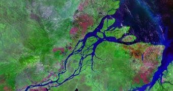
In a new survey of the sediment crust located at the mouth of the Amazon, geologists from Brazil's national oil company Petrobras have determined that the age of the transcontinental river is of about 11 million years old. While, at the beginning, the river looked somewhat different from today, its present shape was achieved some 2.4 million years ago, when this course was settled. The data were collected from sediment samples picked up from two boreholes that the company made where the Amazon met the Atlantic Ocean, ScienceDaily informs.
Geology experts say that, under the mouth of the river, there is a ten-kilometer-thick layer of sediments, known as the Amazon Fan. Despite attempts, it has proven difficult for researchers and investigators to penetrate this layer of sediments in other studies, so as to collect samples from as deep down as possible. Previous drilling has only led scientists, including those in the Ocean Drilling Program, a short distance downwards, but Petrobras' new efforts have managed to considerably extend that depth.
One of the two boreholes that the company drilled starts some 4.5 kilometers below sea level and offers researchers the possibility to investigate both the history of the river and that of the Fan. Alongside Petrobras, other institutions involved in the new drills include the University of Amsterdam Institute for Biodiversity and Ecosystem Dynamics (IBED), and the University of Liverpool. Additionally to offering direct information on the river and its age, the boreholes may also provide insight into how ecosystems on the Atlantic coast evolved, and also on the paleogeography and the evolution of the South American continent as a whole.
Studying estuaries and deltas is a very good method of tracking down the evolution of a large number of geographical factors over the territory the water irrigated over millions of years. Sediments that are accumulated where the water flow meets the sea can tell the story of how much rainfall the land received, what temperatures were recorded in the area at certain times, and much more. However, in some cases, such as those of rivers in the Arctic, it's very difficult to analyze these formations, because boreholes cannot be dug up, with the soil being too tough.

 14 DAY TRIAL //