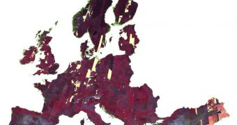
The European Space Agency (ESA) announces the extension of the GMES Space Component Data Access scheme, a measure that will enable broader and more efficient access to a wide range of satellite data collected for the Global Monitoring for Environment and Security (GMES) program.
GMES is primarily destined to make accurate, timely and accessible information readily available to governments, space agencies and other authorities that might need them. Such data could be used in case of emergency, for example.
If a landslide covers an entire village, then satellite data covering the area will be called upon and examined, the layout of the town processed, and emergency response teams directly accordingly.
Through GMES, this process will take minutes or hours tops, not days as is currently the case. In addition, the project will be focused on understanding the changes our planet is going through. This will help authorities figure out how global warming and climate change are affecting the environment.
The data will also provide a new way of keeping track of ecosystems and habitats almost in real-time. As such, data about the effects of a changing climate will become available as they happen, allowing authorities and politicians to make better-informed decisions.
In excess of 40 European and international space missions are being used to set a solid foundation for GMES. The Data Access system of the GMES Space Component is the access point to these data.
“With this GMES Space Component Data Access scheme, Earth observation data are made available in a unified manner to European service providers on Earth’s land, oceans and atmosphere, climate, security and emergency response management,” an ESA press release explains.
“Since the beginning of the data access initiative in 2007, this scheme has provided a wide range of Earth observation data to GMES services,” the document goes on to say.
“This included high-resolution images for the European Urban Atlas, images and data for monitoring land use at European level and delivering validated biophysical products across Europe,” it adds.
In addition, the scheme has also proven more than capable of making radar and optical images available to emergency responders. Solving crisis has become a lot easier since this capability has been made available.
ESA is now starting a new dedicated web-based portal, which will enable more users to have access to GMES data faster than ever before. An online catalog will also be created, which will contain all data categories the system contains.

 14 DAY TRIAL //