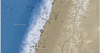
On February 27, a devastating 8.8-magnitude earthquake struck the Chilean coastline. The tremor, which was the seventh strongest ever recorded by modern means, could have caused a lot of damage, but fortunately only minimal casualties were recorded, and damage to infrastructure was not considerable. Immediately after the catastrophe, experts began wondering where its epicenter was, as in where the giant energy release originated. Researchers have now compiled a new map, showing the intricate layout of the tectonic plates at this particular location, LiveScience reports.
The entire nation of Chile is situated in a very dangerous area, on the rim of the Pacific Ring of Fire. This is an area of extremely intense volcanic and seismic activity, given by the fact that some of Earth's largest tectonic plates collide head-on. The Ring stretches from Japan and Russia, to the west of the Pacific Ocean, to the coastlines of North and South America in the east. Around this area, major earthquakes are always a possibility. In the case of Chile, the country is located directly on top of the fault line system connecting the Nazca Plate, in the Pacific, to the South American plate.
These giant slabs of the Earth's surface are in constant motion on top a massive ocean of magma that exists in the planet's mantle. Though they move imperceptibly slow, the motion does exist, and it accounts for all volcanic eruptions and earthquakes in the world. The Ring of Fire is formed through a very simple mechanism. At a large scale, new terrestrial crust is produced from a ridge in the middle of the Atlantic Ocean. This pushes the Americas further west, and the Eurasian plate further east. On the other side of the planet, these two plates essentially squeeze the Pacific plates between them, giving rise to a host of tectonic manifestations along these points of contact.
In Chile, the speed of the subduction process, through which the South American plate moves on top of the Nazca Plate, is estimated to be about 8 centimeter (or 3 inches) per year. This process has been going on here for a while, as it is the main “building force” behind the Andes Mountains. But subduction also reshapes the landscape in surrounding areas, and this was made obvious through the new map. It combines tectonics information, elevation data and ocean contour data, to provide experts with a view on where the recent earthquake may have originated. The fault line that is now considered to be responsible for the event is marked by a red line, and is located some 62 miles (100 km) offshore.

 14 DAY TRIAL //