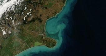
The image above was captured on March 6, 2014, by the Moderate Resolution Imaging Spectroradiometer (MODIS) instrument aboard the NASA Aqua satellite and centers on an area around Christchurch, New Zealand's third most populous city. The region suffered a series of floods in early March, brought on by a very severe storm.
The atmospheric event hit the entirety of South Island between March 4-5, bringing around 7.4 centimeters (3 inches) of rainfall. Heavy precipitations were accompanied by gale-force winds, and this combination of elements led to the flooding of around 100 households. An additional 4,000 homes experienced power outages due to the storm, the MetService announced.
This flood draws attention to a joint initiative between the US National Oceanic and Atmospheric Administration (NOAA) and NASA, which calls on the public to develop software, hardware, and data visualization tools to assess coastal flooding risks. All of these tools will use data from NASA, NOAA, and the US Environmental Protection Agency (EPA) for this monumental task.
New Zealand's floods also draw attention to the fact that coastal communities around the world are becoming increasingly susceptible to damage caused by floods and sea level rise. Scientists have predicted that these effects will occur on account of global warming for many years, but preventive measures were not set in place to ensure damage is minimized.

 14 DAY TRIAL //