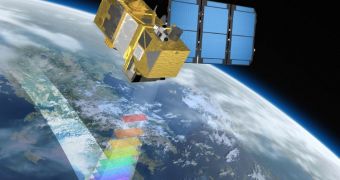
The platform for the European Space Agency's (ESA) Sentinel-2 spacecraft has just been delivered to Astrium’s facilities in Friedrichshafen, Germany, marking a significant milestone in the satellite's development.
The component was manufactured by the aeronautics company CASA in Spain, and was delivered to Astrium for integration and testing. This means that all of its components will be installed here, and the finished spacecraft will then be put to rigorous tests.
Sentinel-2 will carry an advanced suite of scientific instruments, whose primary objective is to monitor land surfaces around the world. The satellite is a part of the new wave of innovative European Earth-monitoring constellations, that will help authorities keep track of land and water use, as well as what goes on in the atmosphere.
Astrium GmbH will get on installing payload instruments and power, communications and navigation systems as soon as possible. The spacecraft needs to be built and tested in such a way that it's ready to take off by 2013. French, German and Spanish companies are involved in this effort.
Together with four other spacecraft of the same class, Sentinel-2 will form the basis of the European Global Monitoring for Environment and Security (GMES) program ESA is currently developing.
“The mission is foreseen as a series of satellites over 20 years, each having a lifetime of more than seven years. The first, which is currently being integrated in Germany, is planned to be launched in 2013,” an ESA press release reads.
“In full operations, two identical satellites will be maintained in the same orbit. The pair of Sentinel-2 satellites will deliver imagery on all land surfaces and coastal zones every five days in cloud-free conditions, and every two to three days in mid-latitudes,” the document ads.
These observations will primarily be used for land monitoring, but additional applications in fields such as emergency response and security services will also be pursued. GMES is therefore shaping up to become one of Europe's most important space assets.
It will first and foremost rely on camera capable of taking high-resolution optical images of the planetary surface, but its satellites will also carry multispectral imagers capable of monitoring swaths of land of up to 290 kilometers (180 miles) at a time.
“The imager provides a versatile set of 13 spectral bands spanning from the visible and near infrared to the shortwave infrared, featuring four spectral bands at 10 [meters], six bands at 20 [meters] and three bands at 60 [meters] spatial resolution,” the agency statement concludes.

 14 DAY TRIAL //