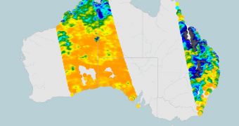
Satellites operated by the European Space Agency (ESA) will form the backbone of a new, early warning flood monitoring system. Earth-observing spacecraft will play a fundamental part in the shaping of new defense mechanisms, meant to avoid bad outcomes following natural crisis.
Climate experts believe that the recent floods in Australia are the result of the atmospheric pattern called La Nina, which is severely influenced by global warming. Given that climate change is happening, developing new, orbital assets for detecting floods in advance is critically-important.
This was made painfully obvious in Queensland, the area of Australia that was hit worst. The magnitude of the disaster is only now beginning to reveal itself, as the waters are receding.
Yet, the thing that stands out clear as daylight is that people cannot afford to be caught off-guard again. Monitoring and warning networks need to be set up as soon as possible, experts and authorities agree.
One possible method of protecting against natural disasters is to augment existing models for monitoring and forecasting floods. ESA has already taken a step in this direction, via a project sponsored by the agency's Data User Element.
Under this initiative, the Advanced Synthetic Aperture Radar (ASAR) instrument on the Envisat satellite will be used to feed data collect from Earth's orbit into existing models, with the sole purpose of increasing their accuracy by a great margin.
The Commonwealth Scientific and Research Organization (CSIRO) of Australia is carrying out this Share project in collaboration with experts from the Vienna University of Technology (VUT).
“As demonstrated by the Share project, SAR data, such as that provided by Envisat and the future Sentinel-1 satellites, can be used in two important ways for flood monitoring,” says VUT expert Wolfgang Wagner.
“Firstly, the data can be used to continuously monitor how much water is stored in the soil as this determines the amount of runoff resulting from rain and secondly, by observing inundated areas during a flood because radar can penetrate through clouds and even rain,” he adds.
The ASAR data will be added to CSIRO-developed systems, which are currently monitoring the progress of floods throughout the country. Optical data combined, passive microwave information and digital elevation models come together in the Australian simulations.
“In Australia we have learned to live with droughts and floods. Extreme floods cause terrible damage, but in other cases floods are vital for our river wetlands and irrigation communities,” explains CSIRO expert Albert van Dijk.
“ESA's radar observations are helping us develop ways to monitor and predict the progression of floods.” he concludes.

 14 DAY TRIAL //