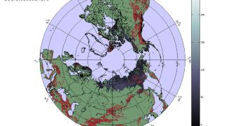
According to officials at the European Space Agency (ESA), the organization will provide support to the general European public during the winter months, by making satellites available for snow monitoring via the GlobSnow project.
The goal of this initiative is to ensure that the people get all the information they need about upcoming weather, and also that they are informed about any potential effects that harsh weather had on various communities or areas.
Keeping an eye on global snow covers is very important, seeing how the stuff can lead to transportation shutdowns, forcing entire cities into a state of paralysis. Floods occur often as well, especially in ares with records of heavy snowfall.
But the global snow cover also plays a critical role in determining and influencing Earth's climate patterns, meteorology patterns, as well as the flow of the water cycle.
Satellites have an easy time keeping track of global snows because most variations occur in the Northern Hemisphere. The southern half of the planet is relatively unaffected in terms of snow cover by season changes.
Throughout the Northern Hemisphere, a water volume of 2000 to 3000 cubic kilometers is affected by the temperature changes that winter brings. The season affects 20 to 40 million square kilometers.
In North America, Europe and Northern Asia, there are very few ground stations capable of recording valid scientific data about snow covers, and so scientists never really developed a comprehensive map and quantification method for snow in this half of the planet.
This is one of the main reasons why GlobSnow was developed. The system encompasses Earth-observations satellites that belong to both ESA and NASA, which allows researchers to get a bird eye's view of the entire planet.
“The one-year, near-real time demonstration service makes information about snow cover and snow amount publicly available online on the GlobSnow website,” ESA says in a press release.
“A number of northern institutes will test the data for use in hydrological modeling, flood forecasting and water resources management,” the statement adds.
“Having access to continuous satellite information of these regions over long periods of time is important for scientists to identify and analyze long-term climatic trends and changes,” it concludes.

 14 DAY TRIAL //