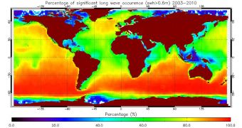
The European Space Agency (ESA) is determined to assist people involved in all aspects of exploiting the world's sea, and one way it could do so was the launch of the GlobWave Project. Its aim is to provide accurate forecasts on the states of the world's seas to anyone demanding it.
Such forecasts have been proven critical for coastal engineering efforts, tourism, coast management, shipping and offshore engineering. But unexpected ocean waves can ruin the work being carried out in all these fields, unless those involved have access to updated data at a moment's notice.
This is precisely what ESA wants to provide through its new service, which utilizes satellite data to create the forecasts. If successful, the initiative could save hundreds of millions of dollars or euros around the world.
Rough seas and waves are a real problem sometimes, and they pose both safety and financial hazards, including damages to fisheries, ship, oil or gas extraction, offshore power plants, artificial fisheries and so on. The effects of coastal erosion must also be considered.
Since NASA put the Skylab space station in Earth's orbit, back in 1973, scientists have had access to radar altimetry data that measured the height of waves. But the data bases were unconsolidated, and an exclusive group of people had access to the information.
Now, data from 11 satellites – some of which have been working since 1985 – have been consolidated into a unique dataset, which ESA makes available through GlobWave. The development of synthetic aperture radar (SAR) instruments was absolutely necessary in order for this to become possible.
All the information those interested need can be accessed through a single portal, in a common format, and at great resolutions. The data are constantly updated, only hours after satellites send back their transmissions to ground stations.
“The role played by GlobWave in providing a one-stop shop for data from multiple satellite missions, ensuring quality standards in the data and generating regular verification reports demonstrates an excellent step forward in the provision of satellite-based observations,” says Dr. Andy Saulter.
“This should allow us to exploit such data readily and with confidence in the future,” adds the expert, who is based at the Met Office, in the United Kingdom.
“As a provider of global operational wave forecasts, the Met Office places a very high value on any observation sources that reliably provide a baseline against which we can validate our predictive models,” he concludes.
The online tool is available at GlobWave.

 14 DAY TRIAL //