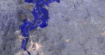
Officials at the European Space Agency (ESA) announce that they are aiding authorities in Pakistan manage the consequences of the disaster floods that struck the country recently.
The waters devastated around 33 percent of the country's surface, affecting an estimate 20 million people. It therefore stands to reason that humanitarian reliefs aimed at the general population are stretched thin.
ESA decided to come to the aid of the Pakistani government, by making available a series of satellite images that can give authorities an idea about the scale of the devastation they are trying to address.
Experts hope that the maps will therefore be able to guide relief efforts, so that the limited amount of resources currently available reaches the people who need them most.
Water-borne diseases are currently the main source of threat, especially for children. According to estimates by the United Nations, 3.5 million children are at risk of developing such diseases.
“Water is a scarce commodity in this devastated region, which is the key for the survival and the well being of millions of children,” says Frank De Winne, an astronaut for ESA.
“Access to clean water is also an important issue on the International Space Station. Technology developed for space applications for water clearance and recycling also have the potential to contribute to a solution,” says the former flight engineer, who is also a Goodwill Ambassador.
He is one of the main supporters of the large-scale efforts the UNICEF is currently undertaking for delivering clean drinking water to all those affected.
The astronaut says that the International Charter Space and the Major Disasters and the Global Monitoring for Environment and Security (GMES) initiative are being used by ESA and the Pakistani government as a framework for sharing data.
The French Spot 5 satellite, and the Medium Resolution Imaging Spectrometer Instrument (MERIS) and Advanced Synthetic Aperture Radar (ASAR) aboard Envisat are used to collect relevant data on the disaster.
These information are centralized into maps, that are delivered to Pakistani authorities. Once delivered to units in the field, the constantly-updated maps contribute to saving lives.

 14 DAY TRIAL //