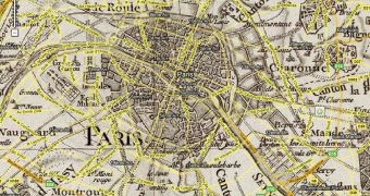
Google Maps has been added a very interesting layer, powered by GeoGarage, representing an 18th century map of France, created by Cassini. It took the cartographer over thirty years to complete his work, the drawing of the 182 sheets of the map.
The layer is fully functional and you can zoom in and out as you please, as you would with a regular Google Map. The interesting part is that it has been added as an overlay on top of the map of France, thus making all the tools provided by Google usable with it, on a topographic scale. It's not just a picture that you look at, you can actually zoom in to the level of highest detail. Any more than that will pass "through" the Cassini map layer and you'll see the regular map, put together by the Google team.
This makes for a perfect "then and now" experiment, for example, by zooming in and out, you will be able to note the differences that have occurred in Paris meanwhile, and how it hasn't changed its historical center all that much. The ability to set the transparency of the overlay at three levels, provided by the people at GeoGarage, will let you do the above without having to zoom, it's a viable alternative if you're interesting in seeing the changes that have occurred in the past 250 years.
The original map was provided courtesy of The David Rumsey Map Collection, which helped on occasion other teams by providing material that can be viewed with Google Maps. An interesting dip into history and the means of detailing just how meticulous the mapping process was before satellites were available. If you had a thing or the traditional knights or if Dumas' Musketeers influenced your childhood, I strongly recommend it. It's not about the same period, but it will bring all that back.

 14 DAY TRIAL //