14 DAY TRIAL //
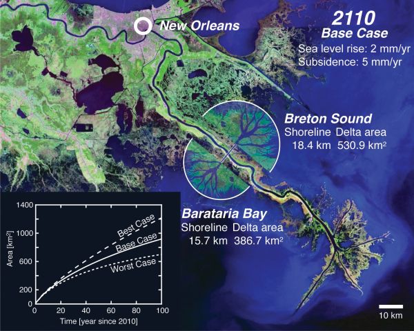
 In a new, long-term plan that stretches about 100 years into the future, engineers write that diverting the sediment-rich waters from the Mississippi River towards New Orleans could result in important, new stretches of land being created around the city over the next century. The river's delta is already shrinking and sinking, and the new scheme would ensure that at least half the acreage that was otherwise expected to disappear would come to be above the water by 2110. The research that has come to the new conclusion has been funded by the US National Science Foundation (NSF).
“What this model shows is that we can, to a large degree, match future land loss by making these diversions,” University of Texas in Austin (UTA) geologist David Mohrig explains. The scientist is also affiliated with the University of Minnesota-based NSF National Center for Earth-surface Dynamics. The research team that compiled the new report believes that the build-up of new land would essentially offer a much-needed protection to areas further North, and that it could help offset some of the losses that will undoubtedly take place as the rest of the Mississippi delta disappears.
“These authors present the possibility that through numerical modeling, coordinated with river channel diversions on the Mississippi Delta, we can begin to restore wetlands and build new land,” NSF Division of Earth Sciences Program Director H. Richard Lane says. Mohrig and UTA geologist Wonsuck Kim have been the leaders of the new study, which appears in the October 20 issue of the American Geophysical Union (AGU) publication Eos.
Since 1940, the Mississippi delta has been losing in excess of 44 square kilometers (17 square miles) of surface per year, on account of the extensive system of levees that the US Army Corps of Engineers built below New Orleans, so as to prevent the large river from flooding the city. The work broke the delicate equilibrium between soil loss and sediment deposition, and, now, engineers can only hope to direct the natural process in the best possible manner, as it cannot be stopped. The new proposal calls for a pair of cuts to be made oppositely to each other in the levees 150 kilometers (93 miles) downstream from New Orleans.