14 DAY TRIAL //
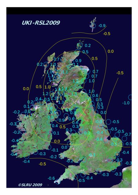
 Experts at the Durham University, in the United Kingdom, have recently devised a new map of the country's coastal lands, which highlights the areas most threatened by sea-level rises. The map charts the post Ice-Age tilt of the UK and Ireland, as well as current, relative sea-level changes in the region. Details of the investigation appear in the latest issue of the Journal “GSA Today.” The research also shows that southern Ireland and Wales, as well as southern and eastern England, continue to sink, while Scotland is still rising, though at rates smaller than previously anticipated.
Core sediments were drilled from 80 locations around the UK, and then carefully analyzed at DU. The research concluded that the relative elevation of sediments was a clear indicator of land rises and falls. The research team also used the carbon-dating technique to assess how and when the sediments formed, data from which they inferred the sea levels of the time. By combining the new knowledge with a special modeling technique, the team was able to obtain a clear map of the UK's future coastline. The model also took into account the amount of ice that was estimated to melt over the next few decades.
“The rate of uplift north of the River Tyne to Scotland increases because the ice sheets there were thicker and heavier. The action of the Ice Age on our landmass has been like squeezing a sponge which eventually regains its shape. The earth’s crust has reacted over thousands of years and is continuing to react. Subsidence and rising sea levels will have implications for people and habitats, and will require action to manage resorts, industrial sites, ports, beaches, salt marshes and wetlands, wildlife and bird migrations,” Professor Ian Shennan, who has been the leader of the research team, explains.
Studies of the sediment cores also revealed that sea levels were higher than today about 7,500 years ago, and that they eventually began to fall about 4,500 years ago. The downward trend has continued to this day, the DU team reports. However, the land is sinking too, the scientists note. Eastern England, for instance, drops at about 0.4 to 0.7 millimeters per year. “When a huge mass of ice melts, the land readjusts over time but there’s also a response in the earth’s mantle and this affects the shape of the surface of the earth’s oceans. Changes in our oceans and land uplift and subsidence will continue to have a significant effect on our coastlines this century,” the DU scientist says.