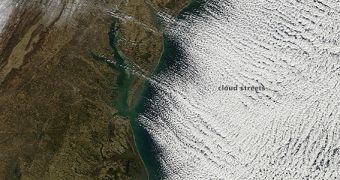
This image collected by the Moderate Resolution Imaging Spectroradiometer (MODIS) instrument on the NASA Terra satellite in low Earth orbit shows long parallel bands of cumulus clouds, flying over the Atlantic Ocean in a type of formation called cloud streets.
The photo was collected on Tuesday, January 7, 2014, as most of the United States (East Coast visible to the left of the image) was fighting the effects of the cold snap. Temperatures over the country dropped by 11 to 22 degrees Celsius (20 to 40 °F) below levels normal for this time of year.
The polar vortex that produced the cold snap may have had a hand in creating these cloud streets as well. These atmospheric formations only occur when very cold air blows over warm water. Another condition that needs to be met in order for the “streets” to occur is the presence of temperature inversion over the two previous layers.
According to climate scientists, the clouds develop if the difference between air and water temperature levels is at least 22 degrees Celsius (40 °F). When the image above was taken, cold winds were blowing from the northwest, where the polar vortex was wreaking havoc over North America.

 14 DAY TRIAL //