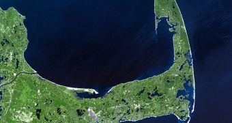
Few people living in Massachusetts or in the United States in general know that Cape Cod was in fact produced by a large glacier, that originated in the Laurentide Ice Sheet.
This large chunk of ice, which disappeared millennia ago, stretched across most of the territory now occupied by Canada, as well as over much of the northern parts of the United States.
All in all, it covered hundreds of thousands of square miles, stretching as far south as New York City, and then following the course of the modern Missouri River until it merged with the Cordilleran Ice Sheet.
The sheet started forming some 95,000 years ago, and endured for quite some time, before finally shrinking and nearly disappearing completely some 20,000 years ago.
For as long as it endured, the ice sheet exerted a significant influence on weather patterns in the part of the Northern Hemisphere, as it interacted with jet streams coming in from the warm Pacific Ocean.
Entire ares of what is now the United States benefited from important rainfalls during that period, something that did not readily happen in many other parts of the world.
The Laurentide Ice Sheet began forming Cape Cod some 16,000 to 20,000 years ago. Both the Cape and the line of islands stretching toward NYC, called the Outer Lands, are nothing more than terminal glacial moraines.
These are structures that can best be described as accumulations of rocks and other solid debris that are usually found at the outer edges of locations where large glaciers and ice sheets once laid.
This is apparent in the large number of kettle hole ponds that can be observed on the Cape today. Dozens of these structures were formed when chunks of sediment-covered ices melted.
These ices came from the Laurentide Sheet, and played a large role in producing infiltrations that eventually taped into the groundwater below. As this happened, new ponds developed.
As a whole, Cape Cod was largely formed from sediments and rocks that glaciers collected from inland, and carried with them until they reached the ocean. Over millennia, the rocks accumulated to form the large structure.
According to the United States Geological Survey (USGS), the thickness of the sediment deposits reaches an average of 200 to 600 feet (60 to 186 meters) all over the area, Our Amazing Planet reports.

 14 DAY TRIAL //