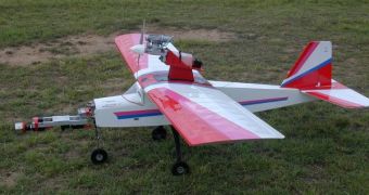
To military applications, Unmanned Aerial Vehicles (UAV) are becoming increasingly indispensable and useful. These aircraft, which are currently flown by remote controls, are able to reach dangerous areas that are deemed too hazardous for human pilots. Their small sizes also make them difficult to detect with conventional radars. But experts in Australia are working on something more than simple RC planes. They are attempting to construct vehicles that are able to “see” the terrain they are flying over for themselves. Such an ability would mean that the UAVs could guide themselves, when flying very low and very fast over complex terrains, PhysOrg reports.
The Australian research group behind the investigation has completed the development of a “stereo” imaging system that it says deals with the problems of distortions that appear in perception at varying speeds. “You know how things that are close seem to speed by, whereas things farther away seem to travel more slowly. Our design eliminates that distortion, enabling us to use the flow of optical data from all parts of the landscape in view to navigate the aircraft, even if it is moving very fast,” University of Queensland expert Richard Moore, the leader of the science team, explains.
The investigators are working with the UQ ARC Vision Center, a division of the Queensland Brain Institute. Their system relies heavily on two advanced cameras, and two highly curved mirrors for obtaining the best possible views of the ground, as it sweeps below. Their main accomplishment was that of creating a data-flow system that allowed for the visual feedback from the cameras to be transmitted to the onboard computer in a continuous flow, in real time. This is the only way in which live adjustments could be made in real time.
“Aircraft have long used gyroscopes to monitor their attitude, but inertial systems are subject to drift over long times. They also don’t like massive acceleration or high levels of vibration. Our visual system is proof against all these things,” UQ engineer Saul Thurrowgood adds. He has led another team in designing an altitude reference system that relies on simply calculating the aircraft's position relative to the horizon. The blue color of the sky is cross-referenced with the green-blue colors on the ground, so the onboard computer can determine if the ship is tilting, or if it’s going up or down.
“It provides an absolute reference to where you are, unlike inertial guidance which infers it from the Earth’s gravity. Trials show our method performs well in varied conditions of cloud, sun, altitude and different imaging systems, and is resistant to false horizon edges such as large trees, sky reflection from lakes or glare when the Sun is in full view,” the engineer concludes.

 14 DAY TRIAL //