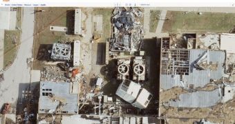
An application on Bing Maps allows users to view in great detail the devastation caused by the deadly tornado that hit Joplin, Missouri on May 22nd, 2011. The imagery used by Microsoft comes from one of the companies that the software giant has already been working with for its mapping platform, Surdex.
With the Joplin Tornado app, Bing Maps users have the chance to witness the damages caused by the natural disaster by comparing the images with photographs taken ahead before the tornado.
Essentially, customers will be able to easily switch back and forward between Surdex’s imagery captured on May 24 and older images of Joplin from August – November 2010. S
“The new Joplin Tornado app documents the massive destruction from the May 22 tornado with extremely high-resolution imagery,” a Bing Maps representative said.
“Surdex, one of our Global Ortho flying partners, captured these images 36 hours after the event at an amazing 7.5 cm resolution (which means each pixel represents an area about the size of a standard post-it note). When you visit the app, you can flip back and forth between the two sets of imagery to better understand the tornado’s devastating power.”
Surdex made the images of the devastated Joplin available free of charge just a few days after the tornado ripped through the US town.
Users are free to download Joplin tornado damage sample imagery, or access Surdex’s own Joplin tornado damage online viewer.
“Because of the nature of the photography and the historical impact of this tornado, Surdex is making the aerial imagery available to the public, free of charge,” Surdex explained.
“The imagery was acquired Tuesday morning, May 24, with a high-definition aerial camera at 3” resolution (better than that captured via helicopter or satellite). Surdex is a leading provider of geospatial data services including aerial imagery and mapping.”

 14 DAY TRIAL //