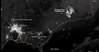
Scientists operating the Suomi NPP satellite have recently used the Visible Infrared Imaging Radiometer Suite (VIIRS) instrument aboard the spacecraft to create a spectacular image of a large bushfire in Australia. This is just one of three fires of this type that burst out this month.
The fires all started on February 9, but the image above was collected by VIIRS on February 10. By Wednesday, the massive Snowy River Complex fire covered an area of 100,000 hectares (390 square miles). The other two fires combined covered an area of 80,000 hectares (305 square miles).
Scientists estimate that the SRC fire probably covers an area larger than the city of Melbourne, located relatively close by. In the NASA Suomi NPP photo, the metropolis is seen flanked by the Morwell-Hernes Oak fire to the east and the Mikelham-Kilmore fire to the north.
Climatologists say that high temperatures and strong winds brought on by a massive summer heat wave are most likely responsible for the three bushfires. At this point, authorities have no solid leads that the fires were started through human neglect.

 14 DAY TRIAL //