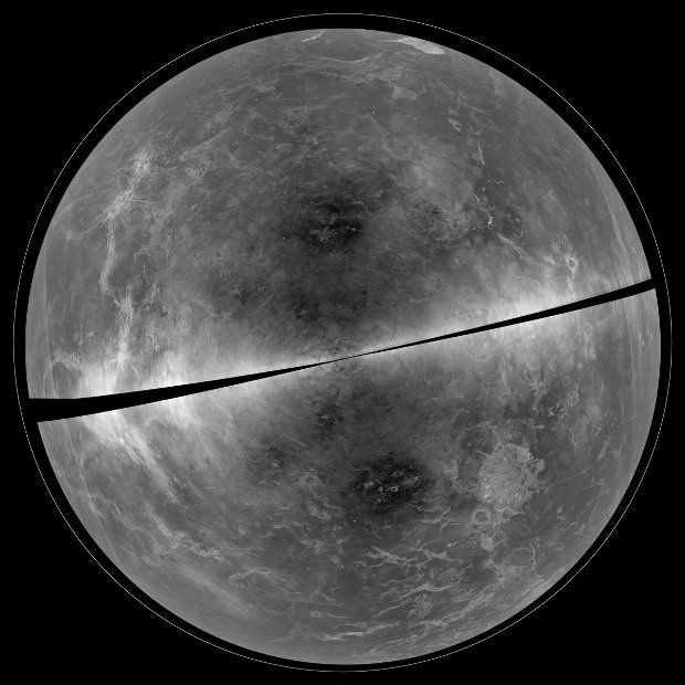
Just yesterday, astronomers with the National Radio Astronomy Observatory in the US released a remarkably detailed view of the surface of Venus, the second closest planet to the Sun and the hottest planet in our Solar System.
The view, available below, comprises images obtained using the National Science Foundation's Green Bank Telescope in West Virginia and the Arecibo Observatory in Puerto Rico.
The instruments made it possible for astronomers to penetrate the thick layer of nearly opaque clouds encompassing Venus and hiding its landscapes from view. The resulting images are said to be among the most detailed ever obtained.
Venus' surface is a dry, barren land
What with its dense clouds obscuring sunlight and average surface temperature of 462 degrees Celsius (863 degrees Fahrenheit), it should not come as a surprise that Venus' surface is dry, barren and not in the least what some would call life-friendly.
The images obtained with the help of the Green Bank Telescope and the Arecibo Observatory, together with past views delivered by probes like the Magellan spacecraft, indicate that Venus sports mountains, craters and volcanoes on its surface.
It could be that oceans were once present on this celestial body, but in this day and age, there are no signs of any such geographical features. If Venus did accommodate for oceans, seas or at least lakes in the past, chances are they were vaporized.
By snapping new images of Venus' surface at regular intervals and closely studying them, astronomers hope to determine whether the volcanoes on this cosmic neighbor of ours are active or dormant. The goal is to gain a better understanding of the planet's evolution.
The same images are expected to also reveal whatever other geological processes shaped Venus in the past and the transformations the planet is currently undergoing. “It is painstaking to compare radar images to search for evidence of change, but the work is ongoing,” said researcher Bruce Campbell.
Studying Venus is tricky business
The National Radio Astronomy Observatory images released this past March 9 were obtained by using the Arecibo Observatory to send radar signals in the direction of Venus and then waiting for them to bounce off its surface.
When returning to Earth, these radar signals were recorded by the Green Bank Telescope. By looking at how their contact with the surface of Venus had upset the radar signals, scientists were able to recreate landscapes lurking under the celestial body's clouds.

 14 DAY TRIAL //

