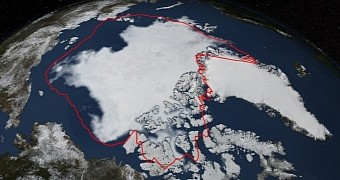
Scientists with NASA say that, this year, the Arctic's sea ice coverage dropped to a considerable degree and eventually hit its sixth lowest extent on record.
Thus, on September 17, the Arctic was documented to have a sea ice coverage of 5.02 million square kilometers (1.94 million square miles). This figure is well below the 1981-2010 average.
To put things into perspective, NASA released an image showing what this year's minimum sea ice coverage in the Arctic looks like when compared to the average recorded over the past decades.
This image, put together using information provided by the Japan Aerospace Exploration Agency GCOM-W1 satellite, is available next to this article. The white patches show this year's ice cover, and the red line marks the 1981-2010 average.
What the Arctic's sea ice was up to this year
According to NASA, sea ice coverage in this part of the world reached it maximum extent for the year 2014 in March. It then began to melt and hit its lowest extent on September 17. Oddly enough, this melting occurred despite the fact that environmental conditions did not exactly encourage ice loss.
“The summer started off relatively cool, and lacked the big storms or persistent winds that can break up ice and increase melting,” researcher Walter Meier says in a statement. “Even with a relatively cool year, the ice is so much thinner than it used to be. It's more susceptible to melting,” he adds.
Truth be told, the minimum sea ice coverage recorded in the Arctic this year is considerably bigger than the one documented in 2012 and 2013. Still, scientists say that this is by no means a good enough reason to believe that global warming and climate change are no longer an issue, and that we can go back to business as usual.
In fact, specialist Walter Meier wishes to stress that, when the historical average is taken into consideration, it becomes clear that the Arctic is well on its way to forever changing its appearance. More precisely, it is losing about 13% of its sea ice per decade.
Not the only bad news in scientific journals
As if learning that the Arctic is gradually turning into one big puddle weren't enough to dump some rain on everybody's parade, it must be said that, according to the US National Oceanic and Atmospheric Administration, this year's August was the hottest ever recorded.
In a report published earlier this month, the Administration details that, according to data at hand, the combined average temperature for both sea and land surfaces in August 2014 was one of 61.45 degrees Fahrenheit (16.35 degrees Celsius), i.e. 1.35 degrees Fahrenheit (0.75 degrees Celsius) higher than the 20th century average.
What this means is that climate change and global warming are progressing at an alarming pace, and that it will not be long now until these phenomena transform the Earth as we know it.

 14 DAY TRIAL //