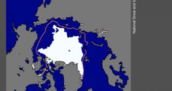
Though this is only a preliminary result, researchers at the US National Snow and Ice Data Center (NSIDC) announce that Arctic sea ice extents have reached their minimum values for this year. The numbers indicate that this is the second-lowest extent in recorded history, after 2007.
According to the team, these figures are in tune with predictions indicating that Arctic ices continue to deteriorate at a rapid pace. The packs keep on losing vast amounts of multi-year ice annually, while recovering to a limited extent the following winter.
Multi-year ices are the oldest and toughest kind in the sheets. They are produced as each year's snow layers become compressed under the weight of new snow. They are the most resilient to melt, and the most difficult to recover the following year.
In the Arctic, the current trend is for multi-year ice to melt during the summer, and be replaced by fast-melting, seasonal ice covers the following winter. When summer comes again, the new ice spreads melt fast, and then the multi-year ices beneath start eroding again.
NSIDC investigators say that the minimum ice extent for any year is usually achieved before mid-September. However, they explain that prevailing winds might still push sea ices together, reducing the extent even further.
A full statistical analysis of ice extents for September will become available in the first week of October, once all the data have been centralized and analyzed. Preliminary results indicate a minimum sea ice extent for September of about 4.3 million square kilometers (1.67 million square miles).
Those values exceed those recorded in September 2007, of 4.17 million square kilometers, or 1.61 million miles, but only by a small margin. The average for 1979-2000 is 6.71 million square kilometers, while the average for 1979-2010 is placed at 6.29 square kilometers.
“While the record low year of 2007 was marked by a combination of weather conditions that favored ice loss (including clearer skies, favorable wind patterns, and warm temperatures), this year has shown more typical weather patterns but continued warmth over the Arctic,” a NSIDC statement explains.
“This supports the idea that the Arctic sea ice cover is continuing to thin. Models and remote sensing data also indicate this is the case,” the investigators add. The new data do not cover all the month of September, however, so the team declares a degree of uncertainty of about 50,000 square kilometers.
“A large area of low concentration ice in the East Siberian Sea, visible in NASA Moderate Resolution Imaging Spectroradiometer (MODIS) imagery, suggests that the ice cover this year is particularly thin and dispersed this year,” the NSIDC press release concludes.

 14 DAY TRIAL //