A group of researchers from the United Kingdom was recently able to determine the actual rate at which Antarctica is losing ice every year. The values the team established are considerably higher than original estimates, based on information collected just a few years ago.
University of Leeds professor Andrew Shepherd led the new investigation, which demonstrated that the West Antarctic Ice Sheet (WAIS) is losing around 150 cubic kilometers (36 cubic miles) of ice per year.
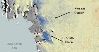
These figures were extracted from datasets provided by the European Space Agency's (ESA) CryoSat satellite, which has been surveying this region for three years. Most of the ice loss occurs as glaciers accelerate their flow into the Amundsen Sea.
Details of the CryoSat investigation were presented earlier this week in San Francisco, California, at the annual meeting of the American Geophysical Union (AGU). The work was conducted by scientists with the UK Natural Environment Research Council’s Center for Polar Observation and Modeling.
Another recent study of the WAIS had demonstrated that this sector of the Antarctic contributed 0.28 millimeters to global sea level rises every year from 2005 to 2010. This means that the world's oceans rose by 1.4 centimeters (0.55 inches) in just 5 years.
The new conclusions suggest that this increase may actually be 15 percent higher than the previous study demonstrated. Ices in Antarctica and Greenland are the main drivers of worldwide sea rise.
“We find that ice thinning continues to be most pronounced along fast-flowing ice streams of this sector and their tributaries, with thinning rates of between 4–8 m per year near to the grounding lines – where the ice streams lift up off the land and begin to float out over the ocean – of the Pine Island, Thwaites and Smith Glaciers,” says University of Leeds scientist Dr. Malcolm McMillan.
“Thanks to its novel instrument design and to its near-polar orbit, CryoSat allows us to survey coastal and high-latitude regions of Antarctica that were beyond the capability of previous altimeter missions, and it seems that these regions are crucial for determining the overall imbalance,” Shepherd adds.
The radar altimeter instrument on CryoSat can conduct studies in the dark, and through fog and clouds, enabling scientists to keep an eye on glacier flows even in harsh weather conditions. The tool can detect minute surface height variations of ice in high resolution.

 14 DAY TRIAL //