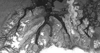
Officials with the European Space Agency (ESA) are proud to announce that the Environmental Satellite (Envisat) spacecraft has just completed its 50,000th orbit around our planet, after being launched to space on February 28, 2002.
Even today, Envisat remains the largest, bulkiest Earth-observations satellite every built and deployed to space. Since it began its science mission, the satellite has traveled in excess of 2.25 billion kilometers (1.39 billion miles) in orbit.
At this point, the 8,211-kilogram (18,100-pound) spacecraft is speeding overhead at an average speed of 7 kilometers (4.3 miles) per second, which is fairly high considering that clarity of the data it returns.
Its 50,000th orbit was completed yesterday, September 22, as it was flying southwards from the Arctic to Antarctica. En route, Envisat managed to catch glimpses of both northern Greenland and New Zealand. The spacecraft has a repeat interval of 35 days.
In addition to holding a record for the largest Earth observer ever, the satellite is also renowned for carrying a vast suite of 10 scientific instruments, which is also a record. Envisat is extremely versatile, as it can analyze land, oceans and atmosphere with the same degree of precision.
Medium Resolution Imaging Spectrometer (MERIS) and the Advanced Synthetic Aperture Radar (ASAR) are the most renowned. They are responsible for capturing colored images of oceans and lands, as well as views that pierce large cloud masses.
ASAR was made famous by its ability to pierce the perennial cloud cover obscuring both polar regions from view. It can analyze the Antarctic rock bed under 3 kilometers (1.86 miles) of ices as well.
Unknown to many, the Michelson Interferometer for Passive Atmospheric Sounding (MPIAS) instrument plays a critical role in monitoring the hole in the ozone layer above Antarctica. Envisat has been compiling periodic reports about it for nearly a decade.
“Trace gases in the troposphere and stratosphere are measured globally by the [SCanning Imaging Absorption spectroMeter for Atmospheric ChartographY – SCIAMACHY], yielding maps of air pollution such as carbon dioxide, methane and nitrogen dioxide,” an ESA press release explains.
“Nitrogen dioxide – a mainly man-made gas – can cause lung damage and respiratory problems. It also plays an important role in atmospheric chemistry because it leads to the production of ozone in the troposphere, the lowest part of the atmosphere,” the statement concludes.

 14 DAY TRIAL //