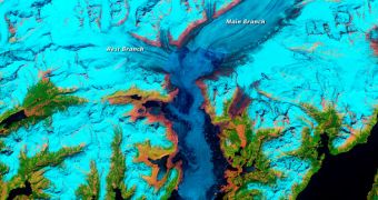
In order to better understand how global warming and climate change influence ecosystems that naturally change at a fast pace, scientists have recently compiled an analysis of the evolution of the Columbia Glacier, in Alaska.
The formation originates in a massive ice field, located around 3,050 meters (10,000 feet) above sea level. It flows on the flanks of the Chugach Mountains, then through a thin inlet, and then into Prince William Sound. It was selected because it is one of the most rapidly changing glaciers in the world.
Another interesting aspect of the glacier is that it's cataloged as a tidewater glacier, which means that it flows directly into the sea. Since British explorers found it, in 1794, the glacier largely remained stable, until 1980. At that time, it began retreating at an accelerated pace, which still continues today.
Experts operating NASA Landsat spacecraft in low-Earth orbit have been monitoring the glacier's activity since 1986, capturing images of its surface at regular intervals. Three different missions, Landsat 4, 5, and 7, were involved in this survey.
The satellites used their Thematic Mapper (TM) and Enhanced Thematic Mapper Plus (ETM+) instruments to collect false-color images of the glacier. These devices detect light in the short wave-infrared, near-infrared, and the green optical portions of the electromagnetic spectrum.
As such, bright cyan colors represent snow and ice, green shows vegetation, light orange and white represent clouds, dark blue designates the ocean, and brown shows the exposed bedrock.
“By 2011, the terminus had retreated more than 20 kilometers (12 miles) to the north, moving past Terentiev Lake and Great Nunatak Peak. In some years, the terminus retreated more than a kilometer, though the pace has been uneven,” experts with the NASA Earth Observatory write.
“The movement of the terminus stalled between 2000 and 2006, for example, because the Great Nunatak Peak and Kadin Peak (directly to the west) constricted the glacier’s movement and held the ice in place,” the statement goes on to say.
Columbia Glacier is now extremely thin. Its thickness decreased directly proportional to the retreat of its terminus. According to estimates, the structure lost 50 percent of its initial volume and thickness over the past 30 years.
“The retreat of the Columbia contributes to global sea-level rise, mostly through iceberg calving. This one glacier accounts for nearly half of the ice loss in the Chugach Mountains. However, the ice losses are not exclusively tied to increasing air and water temperatures,” the NASA group adds.
Climate change and global warming simply nudged the glacier into this frantic level of activity. The calving cycle is now fueled by mechanical processes as well, not just elevated temperatures.

 14 DAY TRIAL //